Page 2 of 2
Re: Flat Earth Theory - An Exploration of Creating Heightmap
Posted: Thu Mar 21, 2013 12:04 pm
by Buffet_of_Lies
jdrew wrote:So let me get this straight, darker colors are short and lighter colors are tall? What do you think the color for 10 voxels tall is? I have also checked out your models tutorial and have to say it is very well made. Thanks for your help ether way.
Yes, you've got the basic concept right. You might find that
this explanation here helps you out a bit. You could probably just count up 10 colors in the color gradient chart here:
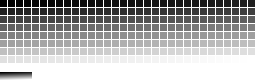
Just sample that color with your color picker tool in whatever program you're using. You might have to mess around with it a bit to get it just right.
Re: Flat Earth Theory - An Exploration of Creating Heightmap
Posted: Thu Mar 21, 2013 4:02 pm
by Jdrew
In the thread simix posted a really good image that was better for me to understand,

Re: Flat Earth Theory - An Exploration of Creating Heightmap
Posted: Thu Mar 21, 2013 5:08 pm
by Buffet_of_Lies
Whatever works. I agree that one is better.
Re: Flat Earth Theory - An Exploration of Creating Heightmap
Posted: Wed Apr 03, 2013 3:56 pm
by Webster
Thanks for the tools Buffet! I've been looking for some map creating tools

Re: Flat Earth Theory - An Exploration of Creating Heightmap
Posted: Sat Apr 13, 2013 6:15 pm
by theginjaninja09
Help! I created my height map and my bitmap, but I can't make them vxl files.
I open converth, but as soon as I press a key it closes down.
Someone please help me!
Re: Flat Earth Theory - An Exploration of Creating Heightmap
Posted: Mon Apr 15, 2013 12:12 pm
by Buffet_of_Lies
theginjaninja09 wrote:Help! I created my height map and my bitmap, but I can't make them vxl files.
I open converth, but as soon as I press a key it closes down.
Someone please help me!
Sorry, didn't see this until just now. Did you edit a batch file with notepad? converth.exe is a command line program so clicking on it will pretty much accomplish nothing. If not that, then are your input files 512X512 24-bit .BMP images?
Re: Flat Earth Theory - An Exploration of Creating Heightmap
Posted: Mon Apr 15, 2013 12:24 pm
by RyanK
Great tutorial Buffet!
Re: Flat Earth Theory - An Exploration of Creating Heightmap
Posted: Tue Apr 16, 2013 6:54 pm
by theginjaninja09
Buffet_of_Lies wrote:theginjaninja09 wrote:Help! I created my height map and my bitmap, but I can't make them vxl files.
I open converth, but as soon as I press a key it closes down.
Someone please help me!
Sorry, didn't see this until just now. Did you edit a batch file with notepad? converth.exe is a command line program so clicking on it will pretty much accomplish nothing. If not that, then are your input files 512X512 24-bit .BMP images?
No, I didn't edit a batch file with notepad.
What is a batch file?
How could I do this?
EDIT: saw the updated tutorial. thanks.
Re: Flat Earth Theory - An Exploration of Creating Heightmap
Posted: Thu Apr 18, 2013 5:58 am
by KomradeKorakoff
Does anyone have the gradient palette that had each height and its corresponding color for the bitmap converter?
Re: Flat Earth Theory - An Exploration of Creating Heightmap
Posted: Thu Apr 18, 2013 11:37 am
by Leif_The_Head
KomradeKorakoff wrote:Does anyone have the gradient palette that had each height and its corresponding color for the bitmap converter?
jdrew wrote:In the thread simix posted a really good image that was better for me to understand,
Re: Flat Earth Theory - An Exploration of Creating Heightmap
Posted: Thu Apr 18, 2013 11:39 am
by Buffet_of_Lies
KomradeKorakoff wrote:Does anyone have the gradient palette that had each height and its corresponding color for the bitmap converter?
Scroll up a few posts?
jdrew wrote:In the thread simix posted a really good image that was better for me to understand,
Re: Flat Earth Theory - An Exploration of Creating Heightmap
Posted: Thu Apr 18, 2013 11:04 pm
by KomradeKorakoff
holy shit congratulations korakoff you're an idiot.
thanks
Re: Flat Earth Theory - An Exploration of Creating Heightmap
Posted: Sun May 19, 2013 2:15 am
by GreaseMonkey
Buffet_of_Lies wrote:TBS wrote:
What I had in mind though, was the classicgen map in the size of pug with water around. And the hills would be slightly lower, like maybe 3/4th. But seriously though, you don't have to make it or anything, unless you really want to, of course.
The size of "pug"?

You might need to explain that better to me. Sounds like a jojoestinky map, though.
If you want the hills lower then, yeah I'd need to probably play around with this in the heightmapper. But I'm willing to take a stab at it. The one problem with me map was that I clipped off too much of the blue side on the left and the blues all spawn in water. But I was just trying out an idea.
Done.

Didn't take long, either.
Code: Select all-rw-rw-r--. 1 ben ben 1048620 May 19 13:04 pug-src.tga
-rw-rw-r--. 1 ben ben 1048621 May 19 13:29 pug-norm.tga
-rw-rw-r--. 1 ben ben 1048622 May 19 13:57 pug-height.tga
-rw-rw-r--. 1 ben ben 2888096 May 19 14:06 pug-img.vxl
The source code is here (coded in fairly portable C). I release these into the public domain. Requires bottom-left uncompressed 512x512 RGBA tga files. ./mknorm <img.tga >norm.tga; ./norm2bump <norm.tga >bump.tga; ./bump2vxl img.tga bump.tga map.vxl. Don't understand it? Don't use it then.